Lelystad, the road appears to cut straight through water. The car’s navigation system calmly suggests you are driving across a lake, yet beyond the glass sit cows, wind turbines, a primary school, and a supermarket. The sky hangs low, the land stretches flat, and everything feels completely ordinary. Only later does it click that, on older maps, none of this land existed above the surface.
A Dutch engineer once remarked, half in jest, that they do not live alongside the sea but negotiate with it. Standing there, it becomes clear this is no figure of speech. It is a long-running agreement, renewed generation after generation.
The Netherlands did more than survive its relationship with water. It quietly rewrote its own geography.
How a Flooded Delta Learned to Redesign Itself
Viewed from above, the Netherlands looks laced with waterways threading across the land. Look closer and something feels off. Rivers bend at sharp angles, vanish into dikes, or end abruptly in man-made lakes. These are not accidents of nature or messy cartography. They are the result of centuries of deliberate work.
This landscape is not random. It is a slow, ongoing construction project that has shaped the country for hundreds of years.
Turning Wild Rivers into Managed Systems
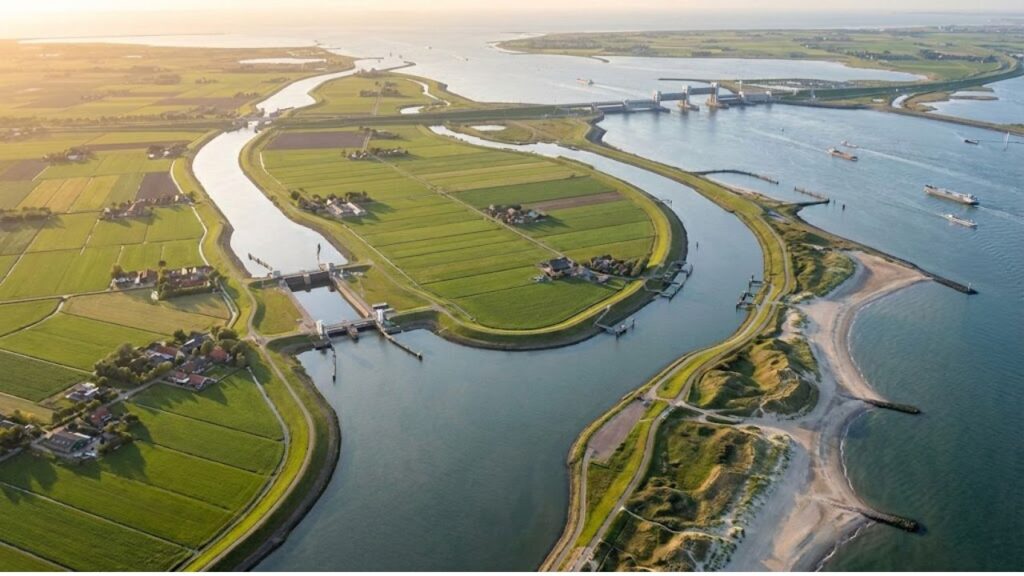
When the Rhine enters the Netherlands, it fractures into branches with different names: the Waal, the IJssel, the Nederrijn. On a map, the pattern looks chaotic. In reality, it is carefully planned. Over nearly eight centuries, engineers redirected and restrained these rivers to ease flooding in one region, protect farmland in another, and maintain vital shipping routes.
During the eighteenth and nineteenth centuries, regulators, weirs, and straightened channels transformed a wandering delta into a controlled hydraulic system. Rivers stopped roaming freely. They were guided.
The logic behind this approach is starkly practical. Much of the Netherlands sits in a low delta where rivers from across Western Europe release their water before meeting the sea. If left alone, those rivers would flood, erode, and shift their paths. Here, even a small change could mean submerged villages or ruined harvests.
So the Dutch began editing the landscape. They cut straighter channels to move water faster, built overflow areas to absorb excess, and raised dikes to keep currents in check. The map became a record of decisions rather than a mirror of nature, shaped with earth, stone, and concrete.
Taking Land from the Sea, One Polder at a Time
Managing rivers was about survival. Reclaiming land was about ambition. A polder is land that once lay underwater, surrounded by dikes and kept dry by pumps. The idea sounds technical, but in practice it feels bold.
- New kitchen technology that expands cooking beyond traditional frying methods.
- Meteorologists tracking a developing cold dome that may deepen early February frost.
- A uniquely modified Boeing 737 designed for operations in the Canadian Arctic.
- A simple three-ingredient method that refreshes grout in minutes.
- Australia setting records with a massive new land-based mobile battery system.
- News surrounding a new separation involving Michael Schumacher.
- The rediscovery of a paleochristian fresco in Turkey after seventeen centuries.
- A traditional rosemary boiling tip said to transform the atmosphere of a home.
The traditional process was straightforward in theory. Engineers built a circular dike, drained the enclosed water using windmills or pumps, and allowed the seabed to dry and settle. Over time, solid ground emerged, often lying several meters below surrounding water levels. People farmed it, built homes, and raised families on land that had once been sea.
The Zuiderzee Project and a National Turning Point
The Zuiderzee was once a vast inland bay cutting deep into the country. Storm surges from the North Sea could rush through it, battering coastal towns. After a devastating flood in 1916, the response shifted from local defenses to a single bold move. In 1932, the Afsluitdijk, a thirty-two-kilometer dam, sealed the bay from the sea.
Behind the dam, saltwater slowly turned fresh, forming the IJsselmeer. Then came new land: the Wieringermeer, the Noordoostpolder, and eventually Flevoland. Cities like Lelystad and Almere, now busy with commuters, were absent from nineteenth-century maps. An entire province emerged as a twentieth-century project shaped from sand and clay.
This calm confidence is striking. Rather than simply building higher walls, the Dutch shifted coastlines, shrank seas into lakes, and redirected rivers that had defined the region for thousands of years. Each step relied on careful studies of soil, elevation, and water behavior, often planned decades in advance.
Most nations accept their coastlines as fixed truths. The Netherlands treated them as working drafts. Yet every adjustment served practical needs: more land for homes, farms, and roads. Each line drawn on the map became part of someone’s daily life.
From Rigid Defenses to Flexible Waterways
For a long time, the strategy was clear: keep water out. Higher dikes, stronger barriers, and sharp divisions between land and sea defined the approach. It worked, until rising sea levels and stronger storms began to expose its limits.
Over the past thirty years, the strategy shifted again. Instead of forcing water into narrower paths, planners began giving it more space.
Making Room for the River
The Room for the River program marked a major change. Floodplains were lowered, side channels were dug, levees were moved inland, and in some cases, buildings were removed. When rivers swell, water can spread safely rather than crashing against rigid walls. The landscape becomes more adaptable.
This transition was not painless. Giving up land or homes is difficult, even when data shows it reduces risk. Authorities had to balance technical models with human stories, explaining why sacrificing space today could mean greater safety tomorrow.
As one planner put it, water always wins when treated as an enemy. The solution was to design with it rather than against it.
- Create bypass channels so floodwaters can split and slow near towns.
- Shift dikes inland to widen critical river sections.
- Convert floodplains into parks, pastures, or nature reserves that can safely flood.
- Use controlled sluices and pumps to manage freshwater during dry periods.
- Combine solid barriers with natural buffers like wetlands and dunes.
Individually, these changes may seem modest. Together, they reshape local life. Farmland becomes river parkland. Old industrial zones turn into walkable waterfronts. A former bend in the river evolves into a wetland that absorbs floods and supports wildlife.
The map continues to change, not through sweeping gestures, but through constant adjustment.
What a Moving Map Reveals About the Future
Standing on a dike near Kinderdijk or the Marker Wadden at sunset, the landscape appears timeless. Windmills turn, reeds sway, and barges drift by. Yet almost everything is managed. Rivers are guided, lakes are regulated, and the ground itself slowly sinks by millimeters each year.
The Dutch experience offers a measured lesson. Geography is not destiny, but it is never fully under control. Rivers can be redirected and seas reshaped, yet climate change pushes water higher and makes old calculations uncertain.
The response is not rooted in spectacle or miracle solutions. It rests on a mindset that treats maps as living documents. Coastlines may be redrawn. Some reclaimed land may eventually be surrendered. Rivers are treated as collaborators, not adversaries.
Coastal regions around the world are watching closely, not to copy every structure, but to adopt the habit of questioning fixed boundaries. The Netherlands quietly altered its own map, leaving behind a question that lingers well beyond its flat horizons.
If negotiation with the sea is possible here, what prevents others from trying?
Key Takeaways from the Dutch Water Story
- Rivers can be redesigned: Redirecting flows and widening riverbeds lowers flood risk and protects communities.
- Land reclamation takes time: Polders and pumping systems require decades of planning and constant care.
- Living with water works: Flexible river systems and wetlands balance safety, nature, and daily life.