The pilot’s voice crackled through the intercom just as the clouds parted, revealing the South China Sea below. Through the window, the water shimmered in pale turquoise, dotted with fishing boats and the occasional tanker. Then a long, straight grey line emerged on the horizon, strikingly unnatural. A runway, suspended in the middle of open sea. Around it lay neat, hexagonal patches of land, like scattered building blocks resting on a blue floor.
None of this existed two decades ago. The airstrip, the harbor, the radar domes and compact military buildings were all created by dredging sand from the seabed and piling it onto living coral reefs. From high above, the scene appears calm. Up close, it feels more like a slow-burning fuse.
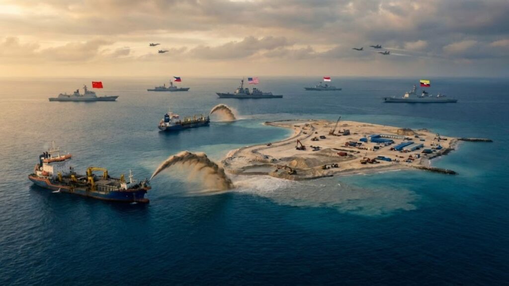
From Bare Reefs to Militarized Islands
For more than ten years, China has steadily reshaped the South China Sea by pouring vast amounts of sand into it. Dredging ships operate around the clock, grinding up the seabed and depositing it onto reefs that once barely surfaced at low tide. Satellite images show the coastline changing month by month, as if the sea itself were being redrawn.
What began as tiny white specks has grown into full-scale islands complete with ports, helipads, radar installations and long concrete runways. The map has shifted not through negotiation, but through machinery and concrete.
Fiery Cross Reef as a Turning Point
Fiery Cross Reef was once little more than a disputed name in official documents. In 2014, it was a thin strip of rock and coral just visible above the waves. By 2017, it had expanded into a 270-hectare island featuring a 3,000-meter runway, large aircraft hangars and missile shelters carved into its structure.
Fishermen from the Philippines recall sheltering near these reefs during storms. Today, they describe encounters with Chinese coast guard ships using water cannons, blinding lights and loudspeaker warnings ordering them away from waters their families fished for generations. For them, the change is deeply personal, affecting whether they return home with a catch or with an empty boat and a warning.
Why These Islands Matter Strategically
For Beijing, the logic behind these islands is precise. Establishing concrete, radar and runways in open water also plants influence along some of the world’s busiest shipping lanes. Nearly one-third of global maritime trade passes through this region, alongside critical undersea cables and potential oil and gas reserves. By fortifying reefs, China extends its reach hundreds of kilometers from its own coast, forming a connected defensive and offensive network.
For neighboring countries such as Vietnam, the Philippines and Malaysia, the message is unsettlingly clear. Legal challenges may continue on paper, but at sea, runways and warships now define reality. That kind of map cannot be erased with words alone.
How Sand Turns Into Power
From an engineering perspective, the process is starkly simple. Large dredging vessels lower suction arms into the seabed, pulling up sand and crushed coral. This mixture is pumped onto selected reefs, where heavy machinery shapes and elevates the land. Once stabilized with rock and concrete, construction crews add roads, buildings and military facilities.
Seen from above, the sites resemble vast coastal construction zones relocated into open water. Cranes swing overhead, trucks crawl along fresh roads, and the surrounding lagoons slowly shift from clear turquoise to cloudy brown.
The Bigger Pattern Beneath the Surface
It is easy to view each new island as an isolated dispute: a single runway, a single radar dome, a single confrontation at sea. Looked at individually, they seem like local incidents. Together, they reveal a broader pattern. Each island extends the operational range of aircraft, missiles and patrol ships. Each harbor reduces dependence on long supply lines from the mainland.
This gradual expansion can be easy to overlook. Few people follow every maritime report or diplomatic statement. Yet the accumulation quietly changes the balance of power.
- Runways and hangars allow fighter jets and bombers to operate far from the mainland.
- Harbors and piers provide fuel, repairs and shelter close to disputed waters.
- Radar domes and sensors expand surveillance across air and sea routes.
- Missile shelters enable rapid deployment of advanced weapons.
- Concrete poured on reefs destroys coral ecosystems and vital fish habitats.
A Crisis Moving in Slow Motion
In cities like Manila and Hanoi, the situation feels far from abstract. Coast guard vessels are rammed, fishermen are pushed away, and reefs disappear under concrete. Each decision at sea involves weighing the risk of confrontation against the need to provide for a family.
Recent incidents have seen Chinese coast guard ships use water cannons against Filipino resupply boats headed for a grounded warship on Second Thomas Shoal. Sailors report near-swamping as smaller vessels take direct hits. Vietnam has raised similar complaints involving ramming and dangerous maneuvers that turn narrow channels into high-stress zones.
After each clash, diplomatic protests follow and tensions briefly ease. But the structures remain, and the next encounter often arrives closer and more intense than the last.
Global Stakes Beyond the Reefs
For the United States and its allies, the expanding network of artificial islands presents a direct challenge. Defense treaties, freedom-of-navigation patrols and joint naval operations underscore the seriousness of the situation. The greatest danger is not a planned conflict, but a miscalculation: a pilot flying too close, a misunderstood radio warning, or a radar lock held a moment too long.
In a crowded sea filled with weapons, ships and suspicion, the boundary between deterrence and disaster can be dangerously thin.
Why This Affects Everyone
From afar, it is tempting to dismiss these developments as distant regional tensions. Yet these islands sit astride major arteries of the global economy. Oil tankers, container ships, raw materials and food supplies all transit nearby. A serious disruption could ripple through supply chains worldwide, raising prices and slowing trade from one continent to another.
There is also a broader implication. If physical control can be established by reshaping land itself, it raises questions about how borders are defined elsewhere. That uncertainty influences how smaller nations assess security, alliances and their own future choices.
Key Takeaways
- China’s artificial islands reshape regional power by extending military reach deep into the South China Sea.
- Everyday confrontations carry real danger, involving treaty allies and major armed forces.
- The environmental cost is immediate, with damaged reefs and lost fishing grounds affecting local communities first.